© National Weather Service Forecast Office
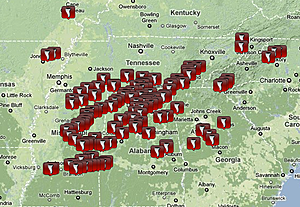
This image shows tornado reports from Wednesday's outbreak. There were more than 160 reports of tornadoes, most of which were in Mississippi, Alabama and Tennessee.
This image shows tornado reports from Wednesday's outbreak. There were more than 160 reports of tornadoes, most of which were in Mississippi, Alabama and Tennessee.
It takes a very particular setup of "ingredients" for a rare event like Wednesday's to happen. What is even more rare is to have setups like this be so repetitious in April, with tornado outbreaks occurring about every few days and yielding nearly 900 reports of tornadoes for this month so far.
"In my 25 years as a meteorologist, this is the worst April I've ever seen," said AccuWeather.com Senior Meteorologist Henry Margusity.
There are several major culprits behind Wednesday's tornado outbreak and the many others that have erupted this month:
150-mph jet stream winds and La Niña
La Niña is a phenomenon that occurs when water temperatures across the equatorial central and eastern Pacific Ocean are below normal. It has a significant influence on weather patterns across the globe.
The current La Niña, which is in a weakening phase after reaching record strength in December 2010, has been causing a very strong jet stream, which is an area of maximum winds high up in the atmosphere, to dip well south across the eastern U.S. this month.
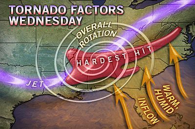
A strong dip in the jet is key in the development of significant severe weather outbreaks, as it supports intense upward motion in the atmosphere and thus powerful thunderstorms. During Wednesday's outbreak, wind speeds within the jet stream across the central part of the country reached 150 mph.
Such a strong jet stream results in intense upward motion in the atmosphere. When the jet moved over warm, humid air in place across the South Wednesday, thunderstorms exploded.
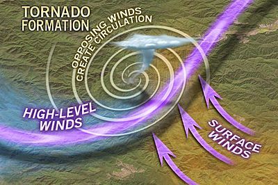
In addition, at the lower levels of the atmosphere (closer to the ground), there were strong winds greater than 50 mph blowing in from the south. With the jet stream winds blowing out of the west and winds closer to the ground blowing out of the south, a strong rotating environment developed.
Once thunderstorms started to erupt, they immediately started to show signs of rotation, which is the first step to tornado development.
Unusually warm Gulf of Mexico for added fuel
Sea surface temperatures across the Gulf of Mexico have been warmer than normal for about a month and a half.
Warm, humid air is a necessary ingredient for severe thunderstorm development, and the Gulf of Mexico is a major supplier of it. The warmer sea surface temperatures are across the Gulf of Mexico, the more warm and humid the air is above it.
All it takes then is for storm systems to draw that warm, humid air northward into the U.S. to serve as fuel for intense thunderstorms. With Wednesday's outbreak, there was a strong low-level flow of warm humid air from the Gulf of Mexico northward into the South.

© National Oceanic and Atmospheric Administration
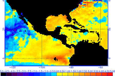
This image shows sea surface temperature anomalies (in degrees Celsius) as of April 28, 2011, with much of the Gulf of Mexico being warmer than normal.
This image shows sea surface temperature anomalies (in degrees Celsius) as of April 28, 2011, with much of the Gulf of Mexico being warmer than normal.
Effect of epic drought in the southern Plains on the atmosphere
The final main culprit in Wednesday's outbreak and others this month has been the presence of dry air at the mid-levels of the atmosphere due to an extreme drought that has been gripping western Texas, New Mexico and Mexico.
The presence of dry air at the mid-levels of the atmosphere (about 9,000 feet above the ground) serves as a "cap" or "lid" on thunderstorms, "containing" them up to a certain point until the cap finally breaks and thunderstorms explode into the violent types that can produce large tornadoes.
This concept is often explained by comparison to heating a pot of water on a stove. If you heat a pot of water without a lid over it, it will boil and produce a steady stream of steam rising above it. If you heat a pot of water with a lid covering it, steam erupts out of the pot when the lid is removed.
If you are still reading here you will probably appreciate this real time jet stream map link.


No comments:
Post a Comment